
Neighbours
DISTRICT | PAGE |
WOODANILLING | BROOMEHILL |
EVENTS | |
ETICUP | |
OTHER | OTHER |
The history of Katanning is tightly intertwined with the towns and districts surrounding it. After Katanning was gazetted settlers began to slowly move outwards to create new communities and new towns.
The construction of the Katanning-Namup railway, followed by an extension to Pingrup, saw the eastern areas grow rapidly. A further branch line connecting Katanning to Bunbury through Kojonup, Boyup Brook and Donnybrook was also opened. This saw the development of the agricultural land between Katanning and Kojonup also develop at a pace. As the rail-head for these two branch lines, Katanning was a major supply centre for these communities, especially for food, perishable goods, medical supplies, and farm equipment.
Many of the people from the various areas married people from adjoining towns and communities making it difficult to separate their history.
These “Neighbours Pages” allow me to include the history of those adjoining towns and communities – some now long gone. Below is a list of place names for this area from the West Australian Government’s “Landgate” website:
BADGEBUP
Latitude 33° 38′ Longitude 117° 54′
A town-site between Katanning and Nyabing , this place was originally proposed as “Badjebupp”, for the name of a station on the Katanning – Nampup (now Nyabing) Railway in 1910. The name is derived from nearby Badgebup Well, and is an Aboriginal word said to mean “place of wild rushes”. Another source gives it as “broad green leaves on a plant round soak”. The Town-site was gazetted as Badjebup and changed to “Nalabup” in 1923, changed back to “Badjebup” in 1923, and finally to Badgebup in 1972.
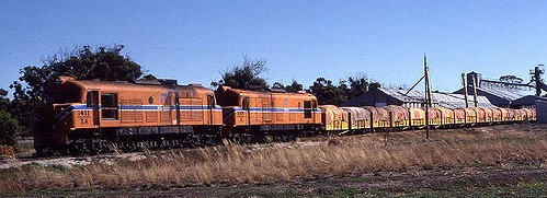
A loaded WAGR grain train departs Badgebup rail siding for Katanning c1970
BROOMEHILL
Latitude 33° 51′ Longitude 117° 38′
The town-site of Broomehill came into existence just before the completion of the Great Southern Railway in 1889. It was given that name to commemorate the fact that Governor and Lady Broome turned the first sods, one at Albany, the other at Beverley. Listed as Broomehill (one word) in railway timetables gazetted in 1889, but as Broome Hill when gazetted a town-site in 1890. Although always locally known as Broomehill, the official spelling was only changed from two words to one word in 1959.
CHINOCUP
Latitude 33° 32′ S Longitude 118° 23′ E
The town-site of Chinocup was declared as “Chinokup” in 1923, to satisfy a need for blocks of land at the station of this name on the Nyabing-Pingrup Railway (now abandoned) The station was named after nearby Lake Chinocup, and the spelling of the town-site was changed in 1962 to agree with the lake. Chinocup is an Aboriginal word of unknown meaning which had been recorded as the name of the lake in 1879.
.
KATANNING
Latitude 33° 42′ S Longitude 117° 33′ E
Katanning is a town-site in the great southern region, 295 km south east of Perth. The name was first used as one of the original stations on the Great Southern Railway when it opened in June 1889. The Western Australian Land Company, who had built the railway, soon developed a private town-site here and, when the government purchased the railway in 1896, it converted the town-site to a government town-site. This was formally gazetted in 1898.
Katanning maybe a local Aboriginal word of uncertain meaning. There has been much conjecture regarding the meaning, with two schools of thought prevailing. One was that the name came from Kart-annin, Kart meaning head and annin meaning meeting place. Thus the name would have meant “meeting place of heads of tribes”. The other was that the name was derived from the name of an Aboriginal woman. Many early local settlers believed this theory, the name of the woman being kay-tan, kate ann or kate anning, although it has been since determined she was born after the name was first used. There is no documentation to support either theory.
KWOBRUP
Latitude 33° 37′ S Longitude 117° 59′ E.
Kwobrup is a town-site in the great southern agricultural region, about 340 km south east of Perth between the towns of Katanning and Nyabing. Like many wheatbelt towns, Kwobrup was first established as a railway siding on the Katanning to Nampup railway opened in 1912. The siding was named Yellanup when the line was opened, but there was concern that the name was too like Yallingup, and there was soon pressure for a name change. The district surveyor suggested “Wollakup” as an alternative, but this was regarded as too similar to Wokalup. He then suggested “Kwobrup”, the Aboriginal name of a nearby swamp first recorded in 1905. This name was also recorded as Quaberup in 1876. A possible meaning of the name is “good place”.
MOOJEBING
Latitude 33° 36′ S Longitude 117° 30′ E
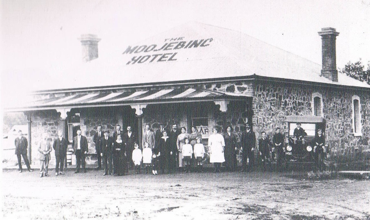
Moojebing Hotel c1910
The town-site of Moojebing is located in the great southern agricultural region, around 260 km south east of Perth between the towns of Woodanilling and Katanning. In the early 1890s the government opened up a lot of land in the Katanning area, including a number of town-sites. Moojebing was one of these, and the town-site was gazetted in 1892. The town-site straddled the Great Southern Railway which opened in 1889, but it was also close to other town sites at Katanning, Woodanilling and Pinwernying. The demand for land was low, and in 1917 much of the town-site area was opened up for agricultural purposes.
Moojebing is an Aboriginal word, believed from Moojebup Spring, a nearby name first recorded in the area in 1874. The meaning of the name is not known, although one source gives it as the “place of moojung birds”. There are no references to a “moojung” bird, and this source is dubious. It may be connected with “moodjar” or “muja”, the Noongar word for the W.A. Christmas Tree, Nuytsia floribunda.
MOORNAMING
Latitude 33° 34′ S Longitude 118° 05′ E
Moornaming is a town-site in the great southern agricultural region, 326 km south east of Perth and 7 km south west of Nyabing. It is situated on the railway line from Katanning to Nyabing. When the line was planned in 1910 and names sought for stations on the line the station in this place was proposed to be named Shannons, after a nearby soak. It was known by this name for a year before the Railways Department proposed it be named Badgeminnup, referred to as the Aboriginal name of the area. This name was adopted in 1912. The same year it was decided to establish a town-site here, and the suggested name of the town-site was Badjeminnup, the more correct spelling from a nearby soak. Badjeminnup town-site was gazetted in 1915.
In 1923 the Railways Department advised that Badjeminnup was being confused with Badgebup, and suggested Badjeminnup be changed. The name Moornaming, an Aboriginal name of the area was suggested by a resident of Badgebup, and the change of the name to Moornaming was gazetted in 1923. The meaning of the name is not known.
NYABING
Latitude 33° 33′ S Longitude 118° 09′ E
The town-site of Nyabing is located in the great southern agricultural region, 319 km south east of Perth, and 51 km south east of Dumbleyung. When the railway from Katanning to this place was planned in 1911, the siding at the terminus was named Nampup, after the Aboriginal name of a nearby soak. The district surveyor for the region had a few lots surveyed at the siding in 1911, and the town-site of Nampup was gazetted in May 1912.
Even before Nampup was gazetted, the Railways Department was complaining that Nampup was too similar to Nannup, and an alternative name was required for the siding. The names Narrara and Wingar were suggested, before W J Rae, the District Surveyor, suggested “Naiabing”, which he advised was “the old native name of Little Nampup Soak”. The Department of Lands & Surveys decided that Nyabing was a simpler spelling, and in December 1912 changed the name of the town-site to Nyabing. Although the name has been variously spelt, as Niaibing, Niabing and Nyabing, none of which appear in vocabularies, it appears that the word could have been derived from the Aboriginal word “ne-yameng” which is the name applied to the everlasting flower -“Helipterum manglessii”.
PINWERNYING
Latitude 33° 39′ S Longitude 117° 32′ E
The town-site of Pinwernying is located in the great southern agricultural region, adjacent to the town of Katanning and 292 km south east of Perth. Katanning was a private town-site, owned by the Western Australian Land Company around 1890, but the government had land reserved nearby at Pinwernying. Demand for government land soon resulted in a subdivision of small agricultural lots, and gazettal of the Pinwernying town-site in 1892. The town-site is named after Pinwernying Soak, the Aboriginal name of a nearby water source first recorded by a surveyor in 1887. The meaning of the name is not known. MAP
WOODANILLING
Latitude 33° 34′ S Longitude 117° 26′ E
The town-site of Woodanilling is located in the great southern agricultural region, 254 km south east of Perth and 24 km north west of Katanning. The town-site is located on the Great Southern Railway, and following the opening of the line in 1889 a siding named Round Pool was opened at what is now Woodanilling. The siding was renamed Yarabin in 1895, and then changed to Woodanilling after the government took over the railway line in 1896.
Land adjoining the railway was opened up by the government for settlers in 1892, and a townsite named Woodanilling was gazetted in February 1892. Lots were surveyed and made available, but there were few sales. In 1897 the Government Land Agent, H S Ranford, recommended enlarging the townsite and surveying more lots, as he considered this would be an important town in the near future. There was considerable growth in the townsite in the 1898-99 period.
Woodanilling is an Aboriginal name, first recorded as the alternative name of Round Pool in 1874. Two possible meanings for the name are “place where the bronze-wing pigeon nests” and “lot of minnows”.
Neighbours
Neighbours. Neighbours. Neighbours. Neighbours. Neighbours. Neighbours. Neighbours.