
Woodanilling
Woodanilling
MENU |
PEOPLE |
SHIRE COUNCIL [ 2 ] |
Woodanilling is a small vibrant town in the Great Southern region of Western Australia, 254 kilometres (158 mi) south of Perth on the Great Southern Highway, 24 kilometres (15 mi) from Katanning and 30 kilometres (19 mi) from Wagin.
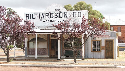
The old Richardson & Co Store
.
The town is in a sheep and grain producing area and was named after a spring in the Boyerine Creek, 1 km south of town. Mallet bark [2] was also exported from the area in large quantities in the 1900s.
The area was first explored by Europeans in 1830-31 in expeditions by Captain Thomas Bannister. The construction of the Albany Highway in the early 1850s and the Great Southern Railway in 1889 brought settlers to the area and helped to establish the town, which was gazetted in 1892. The townsite is located on an old railway siding that was initially known as Round Pool; in 1895 this was renamed to Yarabin and finally changed to Woodanilling in 1896.
The name Woodanilling is Aboriginal in origin and means either “lots of minnows” or “place where the bronze-wing pigeon nests”.
An agricultural hall and public school existed in the town prior to 1903. The school was closed temporarily in 1903 when the teacher, a Mr Campbell, was transferred.
By 1906 the Woodanilling Road Board was cONand the population of the shire swelled to 800 during its most prosperous period from 1905 to 1920. The foundation stone of the local Baptist church was laid in 1908 in front of a large gathering including the local pastor, Rev. W. Kennedy.
The Western Australian Bank branch and new hotel were erected in the town in 1908, along with many improvements being made to the school. Local farmers were confident of a bumper crop after experiencing favourable conditions for the year. The railway station yard was upgraded later the same year, a weighbridge, new crossing, tracking yards and enlarging the current yard were all completed the following year.
The school changed teachers four times in 1908, with finding suitable quarters being the main problem. The school was also enlarged to cater for the growing enrollment.
The local school was destroyed by fire in June 1949, the school had 64 students enrolled at the time. By November the minister of education decided that a new primary school would be built but older students would travel to Katanning for their classes.
.
WOODANILLING PROGRESS ASSOCIATION
Convened by Mr C. Miller, a public meeting was held in the Woodanilling Hall on Wednesday, March 28, to consider that formation of a Progress Association. This was well attended and keen interest was displayed in the suggested purposes of such an association.
These, shortly, are to establish a Display Room in which to house products of the district; to collate all available information regarding diseases of plant and animal life, and methods of eradication; to further the progress of the town and district generally, both socially and agriculturally.
It was resolved that the movement be known as the Woodanilling Co-operative Progress Association, its purpose being the encouragement ot co-operative effort and pooling of knowledge for the common good. Continue reading
.
HISTORY OF WOODANILLING
From the Shire of Woodanilling’s website
Woodanilling was named after a spring in the Boyerine Creek one kilometre south of the townsite. This spring, situated among the Casuarinas and flooded gums, used to flow into a beautiful pool which became a gathering place for the districts new settlers and became known as Round Pool.
The Woodanilling District was first explored by Europeans in 1830/31, when Captain Thomas Bannister led the first overland expedition from Perth to King George III Sound. Governor James Stirling, accompanied by Surveyor General John Septimus Roe visited the area Bannister had explored in 1835. Governor Stirling revisited the area with Alfred Hillman in 1837.
Further exploration of the area was undertaken in 1843 by Henry Landor and Henry Maxwell Lefroy while searching for a large inland sea said to exist south east of York. The lake they found, with the help of Aboriginal guides, is approximately 40 kilometers north east of Woodanilling and was called Dambeling by the Aborigines. This was later changed to Dumbleyung by early European settlers.
The construction of the Perth/Albany Road in the early 1850’s brought the fine grazing lands in this region to the attention of many pastoralists, who took up leases while retaining their permanent properties at places like York.
One of the first to graze sheep in the area was Elijah Quartermaine around 1850/51. Another pioneer to take up the early leases was Edward Hammersley who took up 10,000 acres in 1852.
The Woodanilling area was also a rich source of sandalwood and for many early settlers it was a valuable source of income while they were establishing their homesteads.
Woodanilling was among the many districts to benefit from the opening of the Great Southern Railway in 1889. The Woodanilling townsite was gazetted in 1892. The Woodanilling Road Board was formed in 1906 and had an average population of 800. Around this time Woodanilling could boast a Blacksmith, Wheelwright, five General Stores, Post Office, Banks, Hotel, Hospital, School, Bakery, Church, Barbers, Boarding House, Saddlery Shop, Railway Station, and the first trotting track outside the Perth Metropolitan area.
By 1984 the Shire’s population had diminished to only 470 with a number of factors contributing to the decline, including falling market prices during the 1930 Depression and the demise of the Sandalwood Industry and the amalgamation of farms.
.